Backpacking: the Next Generation

Ready to hit the trail

As we flew into Seattle, the tip of Mt. Baker to the right pierced snowy and pristine through a sludge of atmosphere – a few pristine looking glacier piercing through air that was brown and grimy and disgusting. I’d left Boston weather in the 90s looking forward to the break the Northwest would surely give me, only to land in 95 degree dry heat in Seatac. Wednesday was a blur as all the Camp Grampers arrived, we fed everyone, we stopped to pick up some gear, and then the minute I’d finished the 8 hour journey to Mineral I hopped back in my mom’s car to head up the mountain to Longmire.

Longmire in the heat

It’s a remarkable feeling, to have woken up in Boston and yet found yourself staring up the great rift of Longmire Valley, past Rampart Ridges to the Tahoma glacier. When I walked into the ranger station to get my permit, apparently my face transmitted my depth of feeling. “Are you ok?” asked the ranger?

Back in January, I came up with this scheme. For the first time in what feels like ever, I have a little more vacation than Adam does – 3.5 weeks this year and headed to a full 4 weeks next year. Woooo! And every summer there are three main vacation options: go international (like last year), go to my folks’ house and head down to Ashland, or go to my folk’s house and go backpacking. It’s been many long years since that last option was selected. This year, Adam really wanted to go to Ashland again. But I wanted to go backpacking. Then I had a genius idea – I’d go ahead of time without Adam and go backpacking without him. So I reached out to a guide group and signed up for a guided tour – since backpacking alone is dumb and not ok. Bliss!

In June, I got word from the company that no one else signed up for the tour. Cancelled. AAAAAGH! I came up with plans B, C & D, none of which panned out. So here I was, weeks before the trip, with no plan E. My gaze strayed over at my preternaturally tall 12 year old son. You know, the one who was the right size to carry a pack. And who was the same age I was when I first went backpacking. Hmmm…. I carefully felt him out on the topic “Man, I bet you wish you were a big strong adult who could go backpacking like me!” And … he bit! He said he’d be willing to come with me! Usually willingness to hike with me is a sure sign you’ve never hiked with me before (ask Erin) but then and there we arrived at plan E. Ha!

I was careful selecting my route. My natural inclination is to pick my favorite campsites that are available and hike between them, elevation and distance be darned. Many’s the deathmarch I’ve planned for myself. But I wanted to lure Grey in more slowly – maybe even get him to like this without the use of post-hike hypnotic techniques. So colluding with the Ranger, we picked a very scenic, very satisfying, pretty short trip. We’d spend two nights (so the plan went) at Upper Crystal Lake Campground – a pretty, alpine spot only 3 miles off the road – a dead end with two campsites. Then on the second day, we’d day hike out, and hike out the third day.

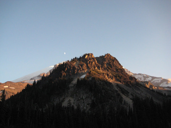
My way back I meandered – using the last light of the preternaturally long day to walk the trail of shadows and breathe the fragrance of firs. I noted with some unease just how haze-obscured Mt. Rainier was, even from the depths of the park, by the smoke. But hey, it beat the heck out of rain, right?

The next morning Grey and I set out at the crack of noon from the trailhead. His first discovery was how amazing water tastes when pulled fresh from a mountain stream, as we refreshed the water we’d brought with us. And oh, it does taste so very good.

Traditional trailhead photo

We were about a mile up the trail (and by up I mean *UP*) when I realized that my carefully procured, conscientiously updated permit was, uh, back down in the car. I ditched my kid and my backpack and headed back down. And then back up again. Did I mention it was 95 degrees? There was a little bit of observational despair when my son learned that we were taking switchbacks ALL the way up the mountain (I’ve gotten smarter in my old age and no longer point out the distant high peak where I suspect we’ll be stopping), but we got past that and the conversation flowed.

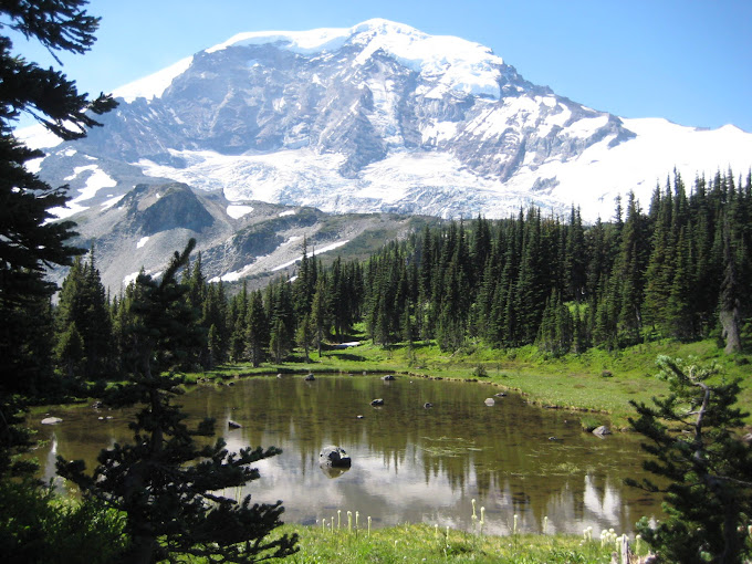
And my, Upper Crystal Lake is a beautiful, beautiful place.

Near where we got our water

We set up camp. We napped. We read our books. We made dinner. (Hiking with a 12 year old sure changes how much food you go through a day!) He taught me how to play spit and Texas Hold’em. I proceeded to get two straight royal flushes and completely wipe him out of hard candy not once, but twice. We fell asleep that night, rain fly off our tent, gazing up at the stars. Before I took my glasses off and roll over, I got to see our tent overflown by the long, silent wings of an owl.

The second morning dawned just as hot. It had cooled off somewhat over night, but we hadn’t slept so much well as long and by the time the sun cleared the mountain walls, the temperature was rising again. There was little shade in the valley, and much bugs. I’d cultivated a blister. And the news from the boots making their way up the valley was that while the mountain – not 20 miles away from us – was currently entirely covered by haze, a cooling, cleansing rain was on its way to the mountains the next day. I prefer to experience my cooling, cleansing rains from indoors, when possible.

It looked like an infinity lake

We took a walk around the lake proper, stopping as is traditional every five minutes to take another picture.

I saw no fish to eat the plentiful bugs

Then we broke up camp and headed back down. And as we got to the bottom, Grey insisted we fill up from that self-same delicious stream to take the water home with us – a precious commodity. And I knew that I’d hooked him.

Backpacking buddy – getting the coldest, fastest water from a mountain stream

You can see all my pictures here!

And oh, what glory filled my soul

Top of the world
Top of the world

When you tell people here in New England that you spent your summer vacation backpacking around an iconic mountain, they tend to think you’re hard core. I like to sprinkle in even more shocking details, saying things like “Yeah, nothing makes you appreciate civilization like a bathroom with walls and unlimited free toilet paper!” (I took a picture of each latrine on the mountain. I think I might make a gallery. You’re welcome.) It does feel impressive, from the land of cubicles.

However, when I was actually backpacking the Wonderland Trail – a 92 mile loop around Mt. Rainier that has so much elevation change it’s equivalent to summiting several times – I did not feel hardcore. Let’s start with the fact we were not doing the whole trail. Adam and I scored an amazing itinerary – absolutely my first choice. But it was only less than a third of the total length of the trail. People have run the Wonderland in the 40 hour range. I actually know some of these lunatics personally. Adam and I were on a pace for maybe a 13 – 14 day Wonderland circumnavigation. We’d stop on the trail and meet someone and they’d ask where we came from and were going. They’d give us a look, and lay out an itinerary often twice the length of ours. Any many of them WERE doing the whole trail.

Two particular meetings come to mind: the three young, map-challenged men we met outside of Mystic Lake around noon who thought they were going to Fire Creek (20 miles and 10,000 ft of elevation change). They weren’t running, so there was no way that they were going to make it. Then there was the dad with his two daughters who were doing the whole trail. The young women were having trouble with their boots, and had done 20 miles, with packs, in flipflops. We handed over our blister packs since our feet were holding up fine and they were in dire straights. These things conspire to make you feel like you’re doing the tourist edition of the trail.

Moonset over Mineral Mountain

Our choice was a good one, however. Adam and I had enough time to linger in some of the loveliest places in the world. We could stop and stare. We could rise when rested, and rest when weary. Our longest day was 10 miles. Our final day out was a mere 2 miles, which eager feet ate up. We never once raced to our goal with nervous eyes measuring the ever decreasing distance between horizon and sun.

The itinerary was this:
Day 1: Sunrise to Berkely Park 2.3 miles
Day 2: Berkely Park to Mystic Lake 10 miles
Day 3: Mystic Lake to Cataract Valley 7 miles
Day 4: Cataract Valley to Eagle’s Roost 5 miles
Day 5: Eagle’s Roost to Mowich Lake (out) 2 miles

The tactical travelogue is probably best enjoyed through the hundreds of pictures that survived the editing process. (The pictures are mostly captioned, so if you’d enjoy a day by day you can go through in slideshow.) Adam patiently stopped over a thousand times for the shutter to open and close.

Mt. Rainier above Mystic Lake

Why do I love this? We could have gone to Ashland for the Shakespeare festival, and stayed in fine accommodations with amazing food. (A fact Adam reminded me of not a few times.) We went through considerable expense and difficulty in order to walk 26 miles up and down the side of a mountain, on the week of our 14th anniversary. Why? It’s an answer I struggle to articulate. Because I can’t see these things anywhere else? Because I challenge my mind constantly and my body hardly ever? Because without the discipline of walking, I can never slow my mind down enough to listen? Because carrying everything you need forces you to embrace simplicity and to be grateful for what you have? Because I do not feel happier than I feel when I turn a corner and stare one of my oldest, deepest friends in the face, and see an aspect of that marvelous mountain I have never seen before? Because I enjoy the right kind of suffering? I’m not sure I ever have fully answered the why of loving to backpack, but I can assure you my heart exulted as soon as my boots hit the trail. (My heart promptly started to work overtime as those boots immediately pulled me up the hill to Frozen Lake.)

Since returning to the email-filled world, I have found myself as I so often do – lying in a hotel bed in some city, mind racing with the challenges of the day. There are few things I resent more than work dreams. So instead I pick a section of path, in my mind, and walk it as close to memory as I can. I pull out as many of the scenes, unwittingly recorded. The sights, the smells, the creak of the pack, the loam underfoot. I see the avalanche lily, the lupine, the columbine, the Jeffrey’s shooting star. I watch the moon setting over Mt. Rainier behind Mineral Mountain. The hike feeds and nourishes my true self, and gives strength for the labors that are needed.

Mysterious flower along the trail

I’ve thought of a thousand things I want to tell you about my five days of bliss. How much I love my purple hiking shirt. How Adam and I learned just how little water people truly need compared to how much they use. Why Eagle’s Roost is so lovely. What it feels like for me to walk in the dark without my contacts. How beautifully my knee held up in extremis. What five days without any sort of internet access was like. How desperately I need a much better point and shoot camera for my next trip. Perhaps those thoughts will sneak out, but I struggle enough just to tell the primary stories, never mind the quirkier, flashing tales that sneak across my mind and are gone in a twinkling. So you shall have to be content with this:

Hymns play through my mind as I walk, unbidden. There is less atmosphere so high to interfere between me and God.

Cairn, looking over Mist Park, headed into Spray Park

Far over the misty mountains bold

Adventures on the West Side Trail, continued

The next morning we awoke (still a bit jetlagged) under cheerfully cloudless blue skies. Amongst the bustle of the morning, I put my contacts in. One of them was torn, due to lack of light when I’d put them away the night before. It was with great relief that I recalled I had actually thought to tuck two new contacts into my pack the night before. No problem! I got the new contact and popped it in.

Or dropped it rather, I thought. Everything was still totally fuzzy, and nothing felt wrong in my eye. I felt all around. I looked everywhere. I called my husband to help. We searched and searched. A tent isn’t that large a place — there was no drain for it to fall down. But we couldn’t find it. I had one spare contact left. If I put it in, I would have no backup, but after fruitless searching, I had no other choice.

I put the second contact in. And I dropped it too, not to be found! But wait! What are the odds of that? I wear contacts every single day. I put them in and take them out no problem. Dropping two in a row and not having them findable? My husband looked at me and said, “Are you SURE it’s not in your eye?” I think you see where this is going. I took one contact of my eye. Then I took a second. I put one back in. I took it out and put the other in. Nothing. Totally out of my element, I left one of the not-helpful contact in and attempted to proceed with my day. It was hard. The information from my bad eye was very confusing. I had trouble judging distances (very bad on the trail with steps down and up, etc.) I kept closing my eye to rest my poor brain. And, in the rush, despite being on the list, I had not packed my glasses.

Disaster. But what could you do? We started hiking anyway.

Between Golden Lakes and North Puyallup is a truly lovely section of trail. There’s an ancient burn area jutting out from the mountain with blueberries, old whitened tree trunks and spectacular views on every side. As we stood with our backs turned to the astonishing mountain that is Rainier and gazed out on the Cascades, I remarked that anywhere else, this Cascade-view would be worthy of its own National Park. The breeze blowed strongly, whisking away the mosquitoes and flies which were our persistent companions this trip. The sun was hot, but the wind blowing off the glaciers was refreshing. It was the sort of trail that seems as though it might go on for many chapters of the story. The only problem was the one-eyedness, and that indeed was a problem, but it couldn’t spoil my delight.

Between Golden Lakes and North Puyallup

We stopped for a break at what my mother and I, on one of our previous (failed) attempts at the West Side had called “Almost There” Creek. It is not, for the record, almost to North Puyallup. It is a lovely example of one of the cascades the mountains are named for. The water is cold and crystal clear, crashing down on rocks and crags with the exuberance of youth. There are deeper pools and white shards of water. It is surrounded on all sides by vast trees in the primes of their fir-existence. For all the glory of the mountain, this little crossing is actually one of my favorite spots on the trail.

North Puyallup Campground, on the other hand, is not. For the record, the toilet is out at the campground and you have to cross a very perilous bridge and walk roughly 1/4 mile to get to the toilet that IS functional. It’s buggy, hot, overgrown and unpleasant. The North Puyallup River roils and boils with dangerous intensity under your feet as you cross the bridge. The walk up out of North Puyallup is another toil. The view of Mt. Rainier is lovely. That’s about all that can be said for it. Unlike the other climbs/descents, this one is largely in a vast gash from a 20 year old avalanche. You walk through switchback after switchback of nasty scrub, full of devil’s club and clingy, itchy bracken. The footing is insecure. The bugs are plentiful and determined. It was, therefore, a great delight when we crested the slope to come to Klapatchee Camground and Aurora Lake.

Klapatchee had the worst bugs of our stay. (Travelers the other direction told us that the bugs at aptly named Devil’s Dream campground were epic. One described them as ‘Biblical’.) We had used our head nets before, but they were critical to any enjoyment of that lovely little lake. Our campground looked out past the Park to the West, and there was an amazing view of Mt. Rainier reflected in shallow Aurora Lake, which was teeming with frogs, tadpoles and water beetles. (We had no cell reception. I was hoping we would. We had no cell reception anywhere.) We read each other “The Hobbit” in the quiet of a starlit tent.

We climbed Aurora Peak, to the right

That night’s dinner was Mexican Style Rice & Chicken by Mountain House. It was bland, but acceptable. The other meals were to be preferred. I also figured out that the spare contact I’d brought with mere were of a prescription +2.75. My prescription is -2.75. I’d ditched the bad contact at Almost There Creek, and things improved.

It took us nearly 2 hours to break camp every morning, but the third day it mattered less. We only had 4 miles to go. Hiking out of Klapatchee Park campground, we saw an enticing trail break away from the Wonderland, without the standard, “This isn’t a trail, don’t walk here” boilerplate that the park service puts up when it doesn’t want you meadow stomping. A careful analysis of the trail even indicated some maintenance, so we decided it would be ok if we checked it out. We dropped our packs on the trail, and headed up Aurora Peak.

Boy, were we glad we dropped them. It was STEEP. It was gorgeous. We walked through fragrant fields of bee-busy lupine in the morning sun. Towards the top, there were dropoffs that made me cling to the trail with all my might. They were likely not survivable. It is a strange thing to do something which is truly perilous — we’re prevented in so much of our lives from doing anything really dangerous (except driving) by guard rails and warning signs. All that was between us and falling to our deaths on the rocks below was our own common sense and a few scraggly flowers. But the view from the top of Aurora Peak was astounding. We could see our paths ahead and behind. We could see as far as the Olympics (sadly it was a bit hazy). It was extremely buggy, so we didn’t linger long. Even our headnets didn’t protect us enough.

The view from Aurora Peak

We took our time crossing St. Andrews Park, then headed down to South Puyallup. For a lowland campground, South Puyallup is lovely. The toilet there is set against these amazing basalt cliffs. There were very few bugs there (to our relief and amazement). The forest canopy is high and deep. The campground is delightful, even if the water could be improved. We got in early, so we had plenty of leisure time. At one point, Adam said, “Brenda, what are you doing?” Lying there, my boots off, looking up at the dancing branches, I sighed deeply and happily replied, “Nothing.”

The amazing basalt cliffs

We ate two dinners that night. These backpacker dinners are only 300 – 400 calories a serving, which is less than I eat for dinner when I’m dieting and NOT enough to feed a body that’s been working as hard as ours did. We didn’t bring enough breakfasts, so I wanted to be as full as possible that night, and I knew that with a hard, 11.5 mile day the next day we’d need our strength. They were both excellent: Mountain House Lasagna with Meat Sauce, and Mountain House Chicken a la King with Noodles.

Even pushing hard, it STILL took us 2 hours to break camp on our out day. We woke up early, but somehow found it was 9 by the time we hit the trail. We had 2.5 uphills and 3 major downhills over 11.5 miles to do. Even without having to make camp at the end, that’s tough. The first vista of the day was Emerald Ridge. It’s one of the oddest places on the trail – a place where you become unnervingly aware that Mt. Rainier is an active volcano. A red scree falls of to your left — ferrous stone left behind by a glacier. To your right these strange moraines — long straight ridges like the ominous backs of sleeping giants. No loam underfoot, only slippy rock, clattering against your ankles and making footing treacherous.

The ferrous glacier-foot of Emerald Ridge

Ominous dragon-back ridges at Emerald Ridge

At the bottom of the downhill comes a vast suspension bridge. This is no section for agoraphobics. It is high. It is narrow. It swings. And there is no 911. It was fun. The uphill afterwards, however, was the most brutal of the trip for me. I knew we needed to make time, so I tried to keep up with Adam’s pace. About halfway I had a litany of why I couldn’t, starting with “I gave birth 9 months ago” and ending with “I have a torn meniscus in my left knee” with a few stops in between.

Not for the faint-hearted

The top of THAT uphill is Indian Henry’s. Indian Henry is a gorgeous area. However, at the best of times it’s extremely buggy. In this bumper year for bugs, it was nearly unendurably so. We pelted through the alpine meadows, glancing back over our shoulders at the mountain as we ran. We hiked with our nets on, which was hot but preferable to the alternatives. (At one point on the journey, a woman told me that if she had $100 she would give it to me for my hat/headnet combination. I wouldn’t have taken it.) We kept pushing through Devil’s Dream, which was truly infested.
The iconic cabin at Indian Henry's

The downhill out of Devil’s Dream was actually not bad. South Puyallup seemed a million years ago. The crossings were tough at Pyramid Creek. The uphill to the top of Rampart Ridge was not so bad. About halfway down Rampart Ridge, we met a couple. I greeted them with the standard backpacker’s greeting, “Where are you headed?” We chatted. Then they said, “Are you Aunt Brenda?” My sweet niece Kay had asked them, they said, if they knew me. The kids were on the trail to meet us. A new wind swept under my weary feet and we fairly flew down the rest of the mountain, until we heard childish voices. My sweet boy Grey ran forward to give (deet-covered, sweaty and smelly) me a big hug. Baz swung his walking stick perilously as he carefully explained what they were doing.

We were home.

I am most myself

Or Adventures in Hiking, Part II

Adam at Mowich River

I think I come closest to being who I really am when I am on the trail. I have a deep, abiding, passionate, and slightly hard to describe love for those Northwest mountains. I take what they are (some of the most spectacular scenery in the world) and layer on top it uncontaminated imaginings from my youth about the mystery, majesty and non-factual histories overlaying the rugged rocks and ancient trees. To tell you how I feel about the Northwest mountains – my mountains – would probably require reams of digital screen, not quite convey what I wanted to feel, and sound like a 13 year old’s Tolkein-inspired fantasy coming from a nostalgic 30 year old. So let me just sum up: they are an ideal of my youth that has not been found wanting with my adult eyes. I love them. And I feel very much as though I belong in those mountains.

The first mile or so is always prosaic, though. My husband and I are no longer 20. We were carrying 40 pound packs down a very steep decline towards the Mowich River under a deep canopy of trees. We were racing daylight, having started at noon with 9.8 miles to go with a major downhill, a major uphill and a more-major-than-I-realized kind of flat to go before we could take our rest.

The downhill was lovely, but unremarkable. The uphill from Mowich River is one of the most consistent and long elevation changes of my memory. We counted. There were 33 switchbacks, many of them quite long. You hear the roar of the river below grow increasingly distant, but there are a good three miles of turning your face to the mountain, walking, and then turning your back on it again.

At last, we broke out of the soft fir-needled path and into daylight. “See! We’re almost there!” I gaily called as we walked between blueberries, bear grass, columbine, lupine and all the familiar flowers of the alpine slope. (The flowers for the entire trip were fantastic and at their prime.)

I thought we were almost there. I was very, very wrong.

That sound you hear is my husband cursing the memory. Erm. It’s possible it was more like 3 miles than one. Oops! Trust me. Two miles, carrying 40 pound packs, at high speed, without enough food (bad planning on that one) and at high elevation? Two miles is a lot. Golden light was streaming into an avalanche-lily strewn meadow as our tired feed pulled us into camp.

A shooting star at Golden Lakes

Lessons learned:

  • We had brought electrolyte solutions that we poured into a small water bottle. This was fantastic for perking us up after expending lots of energy.
  • Watch the map for water. We were fine because I planned ahead, but there wasn’t a drop to be had for about 6 miles.
  • The “Santa Fe Chicken” by Backpacker’s Pantry was extremely tasty and welcomed at the end of the day.

    We left the rain flap off our tent. I kept my contacts in until the last moment so I could watch the stars as I slept on the bones of my beloved mountain. We slept well.

    In our next installment: Good planning comes to naught, mountains majesty, why I’m glad I got the mosquito netting and the rationing of DEET

    Golden Lakes (not pictured: swarms of mosquitos)
    Golden Lakes (not pictured: swarms of mosquitos)

  • The West Side of Mt. Rainier

    See that mountain, son? That's where your parents are headed.
    See that mountain, son? That's where your parents are headed.

    The highlight of my vacation was backpacking the West Side of the Wonderland Trail in Mt. Rainier.

    I knew I wanted to go backpacking during our vacation. I planned out my daydream trip: four days, three nights, all the best campgrounds on the hardest side of the Mountain. I went to the website to watch the melt rates (it can easily still be iced in the first week in August, scuttling a trip for those of us not up-to-date with our ice axes). I checked the reservations log, which showed that pretty much every campground on the Wonderland Trail was booked solid for our entire vacation. I still dared to hope.

    You see (and I almost hesitate to admit this on the internet lest it spur more competition for me), the powers that be reserve 1 camp site per campground a night for last minute, walk up reservations. Longmire, the place to make these reservations, is over 2 hours from Seattle, but less than half an hour from my folk’s house. This is what’s called an unfair advantage.

    The day after we landed, after a nice lie-in (well, for us. My poor parents were up all night because SOMEONE WOKE UP for the day after we arrived at home, at about 1:30 am Pacific.) we trekked up to Longmire with an unscheduled week, and a top priority to get some time on Mt. Rainier. I knew what I wanted, but I also knew it was HIGHLY unlikely I’d get my first choice.

    I filled out the starting negotiation paperwork:

    Day 1 – in at Mowich Lake, camping at Golden Lakes. 9.8 miles
    Day 2 – Golden Lakes to Klapatchee Park. 7.8 miles
    Day 3 – Klapatchee Park to South Puyallup. 3.8 miles
    Day 4 – South Puyallup to Longmire. 11.5 miles

    The Ranger took my paperwork and I settled in for the long negotiation.

    “Golden Lakes … ok, Klapatchee Park … ok, South Puyallup … ok. Yup. It looks like that will work!”

    You could’ve knocked me over with a feather. I felt like I’d won the lottery. I *HAD* won the lottery. Three nights at the best campsites on the West Side — barring Summerland the best in the park?!? On my first try?! I was giddy and fairly floated over the trail to find my parents and tell them the fantastic news.

    It was 3 pm. By the next morning, we had to have bought everything we needed (note: all the stores are over an hour away), packed it in our backpacks, driven to Mowich Lake and gotten ourselves on the trail.

    Thus began … the epic buying spree of no self-control.

    We went to REI, Target, Walgreens and Fred Meyer.

    We bought freeze-dried dinners, sock liners, a water filter insert, iodine pills, mosquito head nets, a new backpacking tent, knee braces (3), sunscreen, candy bars, waterproof matches, caffeine pills and squirty cheese. Among other things. It was 11:30 pm before we got home, our bags lying flaccid and empty on the living room floor.

    The next morning we rose really, really early and started stripping out packaging, stuffing food and gear into our packs. After the most hurried packing ever for a backpacking trip (and in retrospect, a few key omissions and unnecessary items), we piled ourselves and our boys into the car for the long trip to Mowich. I savored my Maple Bar as we drove through scenic Ohop Valley, the mountain peeking periodically around corners. It was a gorgeous hot, clear day.

    We hit the trail head. It took us a while — lots of adjusting of shoes and packs. We poured an exhausted Thane into a baby-backpack on my mom’s back and took a patient but also tired Grey with us a bit down the trail. We swatted flies, not knowing just how much of a prelude to our vacation this would be. We arranged our platypi and tightened our knee-braces.

    We were on the trail.

    To be continued….

    Grey and Thane among the hiking gear
    Grey and Thane among the hiking gear